
Your Complete Guide to the Islands of Paris
Last Updated on 17th July 2026 by Sophie Nadeau
This post may contain affiliate links. Please check out my privacy policy and disclosure for more information.
After the Eiffel Tower, the Arc de Triomphe, and the rest of the usual suspects, there’s one Paris landmark you won’t be able to miss when frequenting the City of Light… And that’s the River Seine! Spanning across the width of the city, directions in Paris are even given by whether something is situated on the ‘right bank’ or the ‘left bank’. But what you may well not know is that there are several islands of Paris, all lying within the Seine and joined to the rest of the French capital via a series of complex and often beautiful bridges.
Geography of the River Seine
The Seine starts in Burgundy, and winds its way through France, traversing Paris, and stretching a distance of close to 500 miles before it reaches the sea, close to the port city of Le Havre. Along the way, it crosses plenty of other French towns and settlements, including the ancient and medieval city of Rouen, which also happens to be the capital of the French region of Normandy.
The French Rivers of Aube, the Yonne, and the Marne also converge into the Seine, just before the river enters Paris. This means that whenever there is a particularly large deluge of rain, frost, or snow, four lots of river water end up having to go through Paris!
Islands of the Seine
Île de la Cité
Home to Notre Dame, Sainte Chapelle, and a plethora of other iconic Parisian attractions, it’s here in Île de la Cité where Paris (or Lutetia as the Romans would have called it) was born. Today, the Paris isle is a must-see for visitors to the city and is home to a plethora of fantastic hotels, eateries, and all the secret spots.
Once linked to the rest of the city via a series of bridges, themselves filled with housing, today Île de la Cité is one of two remaining naturally occurring islands in the Seine. And with a population hovering around just a thousand residents, today the 4th arrondissement remains one of the most elusive postcodes in Paris.
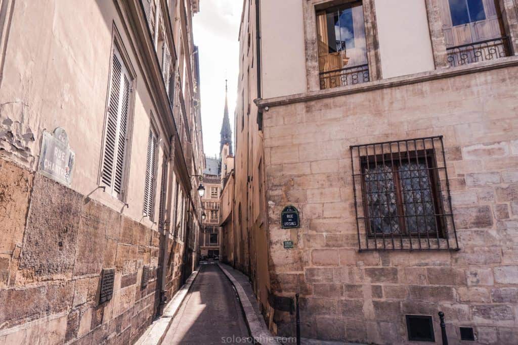
Aside from the many ecclesiastical buildings located on the island, other highlights of Île de la Cité include the medieval rue Chanoinesse, the oldest hospital in Paris (i.e. Hôtel Dieu), the Conciergerie (i.e. where Marie Antoinette was held prior to her execution), and the oldest public clock in Paris.
Île Saint-Louis
Close to Le Marais and adjoined to Île de la Cité via the Pont Saint Louis which lies to the Western end of the island and directly overlooks the Notre Dame. At sunset, this is one of the best places from which to capture photos of the magnificent ecclesiastical building, as well as enjoy quiet sunset strolls in the city.
This Paris Island has some of the most bridges connecting it to the rest of Paris; there are no fewer than five connecting Île Saint-Louis to the Rive Gauche, the Rive Droite, and of course, Île de la Cité.
Some of the main highlights of Île Saint Louis include Berthillon ice cream (hands down the best ice cream to be found in the French capital) and the 17th-century built Eglise Saint-Louis-en-l’Île.
If you’re looking for one of the best picnic spots in Paris, then you simply must head to the Quai aux Fleurs, which offers pretty as a postcard views of Notre Dame Cathedral (which is currently under reconstruction after a devastating fire in April 2019) and dreamy vistas of the Seine.

Île aux Cygnes
The third-largest island of the River Seine is that of Île aux Cygnes. Rather confusingly this man-made Seine isle shouldn’t be confused with ‘Île des Cygnes’ an island which has since been absorbed into the mainland of Paris proper and now forms part of the 7th arrondissement of the city.
Long in appearance, the Paris island of Île aux Cygnes is part of the 15th-arrondissement of the city and was constructed in 1825 so as to protect the Pont de Grenelle, an unusually long bridge which connects the 15th and 16th arrondissements of the city. Perfect for a run or stroll, the green space is best seen in the autumn when the fall foliage is all golden views and beautiful hues.
Île aux Cygnes also happens to be the place where you’ll discover the largest Paris statue of Liberty (there are a handful dotted around the city). A quarter-scale replica of that found in New York, the monument was gifted by the American community in Paris to the people of France just three years after the first one was installed on Ellis Island.

Lost Islands of Paris
Of course, the three large islands which dominate the centre of the River Seine today are not the only isles to have graced the Parisian landmark. In times gone by, there were several isles on the Seine that have since been filled in to join the mainland or have otherwise simply disappeared.
Île des Cygnes
Rather confusingly, as well as Île aux Cygnes (Isle of Swans), there was once the Île des Cygnes. Located where Quai Branly and the museum of the same name are now to be found, the island was previously known as the Maquerelle Island.
However, after Louis XIV introduced several dozen swans onto the island in 1676, the isle was renamed for the birds’ presence. By 1773, it was decided that the gap between the island and the mainland of the Rive Gauche should be filled in and so from 1812, the former island has been part of the fabric of the 7th arrondissement.
Île aux Vaches et Île Notre Dame
There are two Seine Islands that haven’t disappeared but have simply changed form. You see, during the Middle Ages, the Île aux Vaches (Isle of Cows) and the Île Notre Dame were two separate Seine islands to the East of Île de la Cité which were separated by a canal.
However, all this changed in 1614 all this changed when an architect together with two financiers gained the means to construct streets, quays, and a bridge to connect the previously uninhabited islands to the rest of the city. And thus, the modern-day Île Saint-Louis was born!
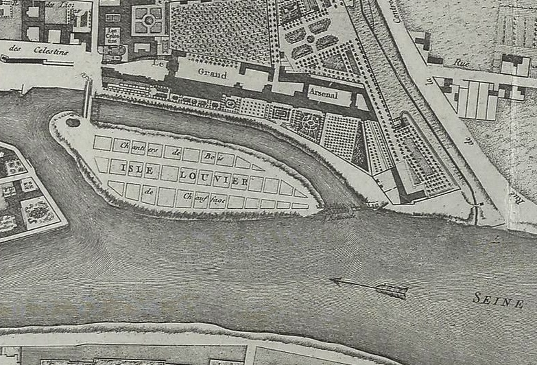
Île Louviers
If you’ve ever wandered along the quay of the right-bank in Le Marais neighbourhood then you’ve probably strolled along a former Seine island without even knowing it! After all, the Île Louviers (also known as the Île aux Javiaux) was once an island whose space between mainland Paris and the isle was filled in during the 18th-century.
During the 15th-century, the island belonged to Nicolas de Louviers, for whom the isle is named. Due to its low lying nature, the island often flooded and was used for pasture. Today, the former isle turned part of mainland Paris is to be found between Boulevard Morland and Quai Henry IV. Of all the islands of Paris, this is well and truly the most lost!
Flooding of the Seine
Dating back to way before the Roman Empire, before the Seine was gifted its current name, and when the city was still known as Lutetia, Paris still flooded on a grand scale just as often as it does now. That is to say, once or twice every decade or so.
In the very centre of the city, not far from where the Eiffel Tower graces the skyline, there’s one statue which is used by locals to gauge the severity of the flooding. Used as a local‘yardstick’ of sorts, the stone likeness of a soldier under Pont Alma, and known as‘the Zouave’ indicates just how high the water has risen.

8.62 metres high was how tall the river rose in the great flood of the Seine in 1910. The water level reached the soldier’s shoulders. To give you an indication, whenever the water rises to the soldier’s shoes, the Seine is closed for boats. In 2015, the water rose to a total of 6.5 metres above the normal level, reaching the statue’s waist.
Notable flood years in Paris
Apart from the recent floods of 2016, 2018, 2021, and the flood of 1910, severe flooding in Paris of the Seine in the past century took place in 1924, 1955, 1982, and 1999–2000.
The Great Seine Flood of 1910
One of the greatest Paris floodings of all time occurred in 1910, and records suggest that it was reminiscent of an even greater flood that happened in 1658. Luckily, no casualties were reported and Parisians stuck together in solidarity to make it through the murky depths of the rising Seine.
In total, the flood lasted over a month and a half and affected almost every part of Paris, as well as its environs (i.e. surroundings). The metro was closed for month upon month. Heavy snow, rainstorms, already saturated water tables all contributed to an estimated damage to the economy of 1.6 billion euros worth in today’s money.
The city was transformed from the City of Light, and into the City of Canals. Sandbanks along the Seine form a barrier to protect the Louvre Museum, in the 1e arrondissement of the city.
Today, small markings have been made on the side of buildings and storefronts to commemorate the flooding in Paris which submerged so much of the city in the early 20th-century. One of the best places to spy one of these little plaques can be found on Rue des Chantres, a pretty and narrow street on Île de la Cité.
Watch the islands of Paris video
Enjoyed reading this guide to the islands of Paris? Pin this article now, read it again later:



Great article!!